Most of what a crew learns about the ground on a dig is known for a day, perhaps a week, and then it disappears under the backfill. The foreman remembers it. The lad who swung the spade remembers it. Then the job finishes, the crew moves on, and the next team to open that ground starts from the same drawings as everyone before them.
This guide is for groundworks and utility contractors and the site managers who run them. It covers why recording what you uncover is worth the few minutes it takes, what a useful record contains, the habits that keep records usable, and how to hand them over at the end of a job.
Why recording what you uncover matters
Utility searches tell you what asset owners have registered. Locators tell you what a signal suggests is there. A trial hole tells you what is actually in the ground at one point. Of those three, only the last is direct evidence, and it is the one that most often goes unrecorded.
Two groups benefit when it is written down.
The next crew
Ground that has been dug once is often dug again: a connection, a repair, a second phase, a different contractor. If the first crew found an unmarked duct and mentioned it only in conversation, the second crew has no way of knowing. A clear record means the next team starts with something better than the plan alone, and can see how much weight it deserves.
The client and the file
Clients and principal contractors often want an as-built picture of what was found, not only what was installed. If a service is later damaged, or a question is raised about what was known at the time, a dated, attributable record with photos is far more useful than recollection.
None of this replaces the checks you do before and during excavation. It sits alongside them. Searches, scanning, trial holes and safe digging practice come first. The record is what you leave behind afterwards.
What a useful record contains
A pin on a map is a start, but a pin on its own raises more questions than it answers. A record that the next person can rely on answers these:
- Where is it? A position, plus an honest statement of how well that position is known.
- How deep? Depth to the top of the service, and whether it was measured, estimated or taken from a drawing.
- What is it? Utility type, apparent material, size or number of ducts, and any warning tape, tiles or protection above it.
- Which way does it run? Direction at the point you exposed it, and where it continues.
- How was it located? Trial hole, locator, a drawing, an owner's representative on site. This is the line people skip, and it is the one that tells the next reader how far to trust the rest.
- Which enquiries did you rely on? The reference numbers for the searches you ran, so the record ties back to the paperwork.
- Photos. Wide enough to show where it is, close enough to show what it is.
- Who, and when? A name and a date. Records without them lose weight quickly.
Also record what you expected and did not find. If the plans showed a main across the trench and the trial hole found nothing, say so, with the position and depth. It is information the next crew would want.
Habits that keep records usable
The best record is the one that actually gets made. These habits are simple, and they work on most sites.
Record before it is covered
Make it a rule that nothing is backfilled over an exposed service until it has been photographed and logged. Build it into the same moment as the final check before reinstatement, so it becomes part of finishing the hole rather than extra work afterwards.
Put something in the photo for scale
A tape, a rule or a spade handle next to the service makes depth and size readable. Take one photo that shows the location in context, such as a kerb, a fence line or a manhole, and one close up. Add arrows or notes to point out what matters, so the photo explains itself to someone who was not there.
Say how sure you are
Record the method and be honest about it. "Exposed by hand, depth measured to top of duct" is a very different statement from "signal picked up here, depth estimated". Both are useful. They just should not be mistaken for each other.
The same applies to position. A phone's satellite fix is good enough to put a marker near the right spot, but it is not a survey, and it can be poor under tree cover, beside tall buildings or in a deep trench. Note the accuracy the device reports, and where a position matters, tie it to something fixed by measurement.
Capture it where the work happens
Records written up in the cabin at the end of the day lose detail. If your crew can log a find in the trench with gloves on, the details are fresh and the photos are taken while the hole is still open. Signal on site is often poor, so use a tool that works offline and syncs later, and do not rely on getting a connection.
Keep corrections visible
Sometimes a position is wrong and needs to move. Keep the original and note the change, with the reason, so anyone reading later can see what was first recorded and what was changed.
Treat unknown services as live
If you find something that is not on any plan, stop, make the area safe and follow your company procedure, including contacting the asset owner where you can. Assume it is live until the owner says otherwise. Record it once the situation is under control.
Handing records over
A record that stays on one person's phone, or in a folder nobody opens, does little good. At handover, the client and the principal contractor usually want one clear document rather than a pile of photos. A good handover pack includes:
- A cover with the site, client, dates and contractor details.
- A summary and a plan or map showing where each item was recorded.
- A register listing every item, with type, depth, position and how it was located.
- A sheet for each item, with its photos and notes.
- An appendix of evidence, so the register can be checked against the original photos and entries.
Agree the format with the client at the start of the job, and work to their requirements if they have any. Where an employer's information requirements or a survey specification asks for surveyed positions, a phone record will not provide that. A BSI-published specification, PAS 128, covers underground utility detection, verification and location surveys, so check it, and your competent person, for what a surveyed deliverable involves.
Subcontractors often need to see the records without being added to your systems. Give them read-only access to the specific site, rather than emailing screenshots that go out of date.
Where GroundPin fits
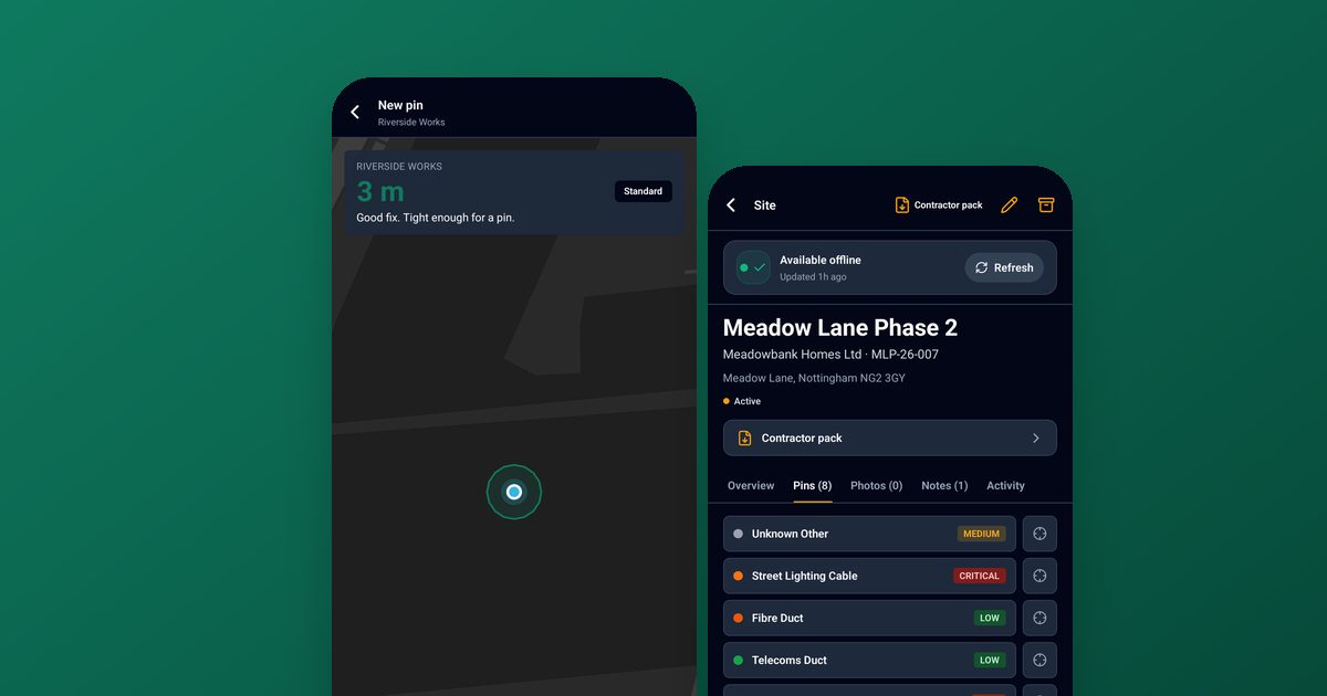
We built GroundPin for this job. Crews drop a pin on their phone, see a graded accuracy for the fix (Good is under 5 m, Fair is 5 to under 15 m, Poor is 15 m or more), add photos and annotate them, and record how the service was located, any offset, the locator used, depth and their LSBUD or NUAR enquiry reference. The grade is a grade of the phone's reported accuracy. It is not a survey.
It works offline, so a site can be downloaded before you lose signal and edits and photos sync when you are back. A photo that was not taken at the pin's fix is badged “Not taken at this fix”, so it is not mistaken for evidence of that position. When a position is moved, the old and new coordinates are kept.
At handover, the Contractor Pack exports a PDF with a cover, summary, maps, register, pin sheets and an evidence appendix, branded for your organisation. Pin records and photos are hashed. You can look at a sample pack before deciding if it suits you. Subcontractors can view a site through a share link without taking a seat.
To be clear about what it is not: GroundPin does not locate buried services and does not give clearance to dig. It works alongside utility searches such as LSBUD and NUAR, CAT scanning and safe digging practice. It records what your crew finds so the next crew has it. There is a free plan with 25 pins and 3 sites, and no card is needed.
PAS 128 is published by BSI. GroundPin is independent and is not endorsed by or affiliated with BSI.
A simple starting routine
If you do nothing else, try this on your next job:
- Run your searches and note the enquiry references before the dig starts.
- Photograph and log every service you expose, with scale and context, before backfill.
- Record how each one was located, and be honest about the method.
- Produce a single handover document at the end of the job.
Check the current guidance from HSE and your client's requirements, and speak to your responsible person or competent person about your own procedures. This article is general advice, not a substitute for them.
Frequently asked questions
Does recording a service mean it is safe to dig near it?
No. A record shows what was found at one point and time. It does not show that the ground is clear, and it should never be read as permission to dig. Searches, scanning, trial holes and safe digging practice still apply on every dig.
How accurate is a phone for recording a position?
It depends on the sky view, nearby structures and the device. A phone fix can place a marker near the right spot, but it is not a survey. Note the accuracy the device reports, and use measurements to fixed features where the position matters.
What should I put in the enquiry reference field?
The reference number from the search you relied on, such as an LSBUD or NUAR enquiry, so the record can be traced back to the original returns. Add any other references your client uses.
Can subcontractors see the records without a login?
In GroundPin, a share link gives a subcontractor view access to a site without taking a seat.
Is there a free way to try this?
GroundPin has a free plan with 25 pins and 3 sites, and no card is needed. It is on iPhone and Android.